<< Back to Press Releases
Malawi Mining Review
Malawi Operations: SacOil conducts environmental screening for Block 1 oil prospecting
Source: Mining Review (Malawi) – February 2014
SacOil was awarded Block 1, located in the North-Western part of Malawi bordering Tanzania to the north and Zambia to the west, in December 2012. At 12, 265 square kilometres, Block 1 is the second largest petroleum exploration license demarcated in Malawi. SacOil has an exclusive 100% interest and operator status for this license.
The block is located on trend with the East African rift system, which is a proven exploration province with prolific oil discoveries in Sudan, Chad, Kenya and Uganda. At the beginning of 2013, SacOil initiated an environmental risk screening study with the assistance of Golder Associates.
The aim of this study was to:
1. Provide a basis for focussing further, more detailed environmental and social follow-up and exploration planning;
2. Develop a GIS geodata-base of the exploration area to assist in planning of the exploration program and to support decisions related to environmental, social, technical risks, non-technical risks and overall logistics of conducting operations in the area;
3. Create actionable and spatially explicit information related to the above that can be shared and utilised on an ongoing basis in GIS software platforms;
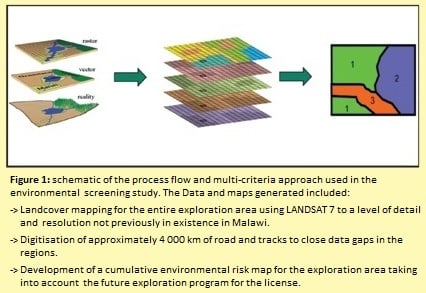
4. Develop a sound information platform for further potential baseline studies. The study was desktop-based and utilised GIS and remote sensing technologies. The study made use of datasets primarily from the following sources:
- Public domain base spatial data (which included but limited to topography, demographic, transport, infrastructure, settlement, administrative boundaries, protected areas);
- Remotely sensed land cover / feature extraction (Landcover features were extracted using a mosaic of the best image tiles covering the entire study area, and extending to the Lake Malawi shoreline on the eastern edge of the block.)
- This work will utilise specialist remote sensing techniques, and will create a level of detail of spatial data currently not available in this region, and
- Legacy exploration datasets such as geo-referenced gravity and magnetic data as well as general mineral resources maps.
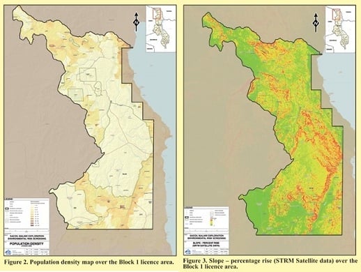
A suite of screening criteria were developed to represent the various technical, environmental or social aspects of the screening study. These criteria were grouped as either negative criteria (less prospective and avoidance) or positive criteria (exploration target or other positive technical criteria).
The study was executed using multi-criteria analysis approach, mapping cumulative risk scores using the rating of approximately 30 risk and opportunity criteria spanning the environmental, technical and social dimensions.
The cumulative risks and opportunity criteria were grouped into 3 categories, namely:
1. Exclusion criteria – These typically include protected areas or areas technically less prospective, etc.
2. Repulsion (avoidance) criteria – These typically include sub-optimal areas in terms of biophysical, social or technical characteristics (e.g. sensitive habitats, slope, agricultural areas, etc). Also termed avoidance criteria in common environmental nomenclature.
3. Attraction criteria – These may be technically or strategically advantageous areas such as roads, rail, cleared or already exploration approved land, etc.

Headlines
IMPORTANT NOTICE TO SHAREHOLDERS REGARDING THEIR SHARES
If you are in any doubt as to what action you should take, consult your CSDP, Broker, Banker, Legal Adviser, Accountant or other professional advisers immediately.
Or visit our Shareholder Information page for more information regarding your shareholding and share certificate.